

Stockton’s Coastal Research Center: Beach Dunes Protected NJ Shore Communities Against Hurricane Sandy
On Jan 20, 2015The Richard Stockton College of New Jersey’s Coastal Research Center (CRC) found that the highest and widest dunes with the greatest volume of sand were the best lifeguards in preserving New Jersey’s coastal communities from the forces of Hurricane Sandy.
A peer-reviewed article titled “Hurricane Sandy: Beach-dune performance at New Jersey Beach Profile Network sites,” by the Coastal Research Center’s Daniel Barone, director of research, Kimberly McKenna, coastal geologist, and Dr. Stewart Farrell, director of coastal research, was published this month in the journal “Shore & Beach.”
When Sandy accelerated toward Atlantic County, making landfall on Oct. 29, 2012, the Coastal Research Center was already in the midst of its biannual fall beach profiling surveys.
Sandy shifted sands along the 210-mile stretch of Atlantic Ocean, Delaware Bay and Raritan Bay shorelines, consequently redirecting the center’s priority to collecting post-storm data as quickly as possible.
The center analyzed 105 locations in the New Jersey Beach Profile Network (NJBPN), with at least one site located in each oceanfront municipality, to determine how beach dunes protected coastal communities against Hurricane Sandy. The New Jersey Department of Environmental Protection’s Bureau of Coastal Engineering sponsored the beach-dune performance research.
The research concluded that dunes and beaches with high elevations and enough volume and width to absorb Sandy’s storm surge and wave energy were able to protect the developed land just beyond the dunes. Homeowners who complied with regulations set by the National Flood Insurance Program by raising structures and limiting the number of items below base flood level lost less and in most cases were able to move back into their homes after the storm.
Twenty-six survey sites were located within federal shore protection projects that consisted of engineered dunes constructed after 2006, and only one of those profiles showed dune failure. Twenty out of the 37 profiles with non-engineered beach-dune systems experienced dune failure.
“We were in the middle of fall surveys when Sandy hit. Right after, Dr. Farrell deployed the entire Coastal Research Center to profile every site. Three to four teams traveled to different counties daily to profile the beaches, and student workers helped to collect data,” said Barone.
Within two weeks following Sandy, nearly all of the 105 NJBPN sites were surveyed to document changes in the shoreline and sand volume losses.
All but 14 of the sites had been surveyed just prior to Sandy, so post-storm comparisons were made against either fall or spring 2012 pre-storm profiles.
In general, the research found that the hardest hit beaches were north of the storm’s landfall in Ocean and Monmouth counties, and the greatest loss of beach-dune sands of the 105 sites occurred in Mantoloking, 300 feet from the temporary channel that opened during the storm.
A favorable switch in wind direction spared the state’s southernmost beaches in Cape May County by decreasing the impact of the second high tide and reducing wave heights.
Wildwood, home to the widest municipal beach in the state, suffered from wave and storm surge damages due to the absence of beach dunes.
“A review of the 105 sites found that three locations in Cape May City actually gained sand on the beach as a result of Sandy, while north of Long Beach Island, the beach retreat exceeded 100 feet frequently. Follow-up study has demonstrated 65 to 80 percent natural recovery in beach sand volume, but dunes had to be physically rebuilt because natural growth is too slow to be prepared for another storm. All U.S. Army Corps of Engineers authorized shore protection projects have been restored as of 2014,” said Farrell.
Farrell explained that it takes about 25 years for a dune to naturally build up to a decent size and that natural dunes aren’t consistently the same elevation.
The results of the research “clearly showed the benefits of beach-dune systems as shore protection features in reducing storm damages to adjacent oceanfront communities and present a valuable data set and analysis that can be utilized by coastal scientists nationally and abroad for many years to come,” said Barone.
Barone added that shore communities can help to maintain their dune structures by planting dune vegetation and installing dune fencing.
The article noted that New Jersey’s shore towns have accommodated beach-goers since as early as the 1800s and play a significant role in the multi-billion tourism industry.
Shore development surged after property prices plummeted following the March 1962 storm.
The Coastal Research Center is nationally and internationally recognized as a leader in assisting federal, state and municipal governments with coastal environmental issues related to recurring storm damage and shoreline retreat. The center established the New Jersey Beach Profile Network in 1986 and has been collecting profile data at its 105 sites and monitoring shoreline trends for nearly three decades.
To collect profile data, a laser range finder unit is set up on a dune and then field assistants traverse the beach from the back dune all the way into the water to a depth of 15 feet holding an optical prism mounted to a range pole. Each beach profile is represented by 35 to 55 data points.
Related Articles: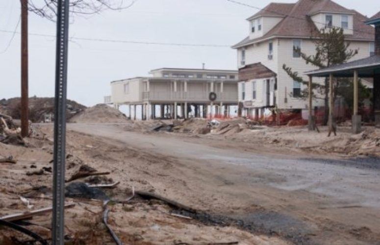


- Accounting
- Banking / Financial
- Coronavirus
- Diversity
- Economic Development
- Economy
- Energy
- Environment
- General Business
- Government
- Healthcare
- High-Tech
- Higher Ed
- Infrastructure
- Labor
- Law
- Life Sciences
- Manufacturing
- Meeting Places
- New Hire/Promotion
- Philanthropy
- Real Estate
- Science & Technology
- Small Business
- Tourism
- Workforce Development
- Special Sections
- Sponsored Content
